

by Joseph P. Farrell, Giza Death Star:
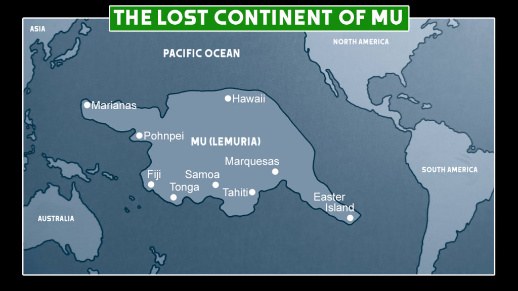
It was British author James Churchward (1851-1936) who popularized the idea of a “Pacific Atlantis” with his entertaining – and almost entirely misplaced – books on that lost continent, a continent he called “Mu”, and which he located in the vast Pacific basin between Hawaii and the Australian shelf and Easter Island. Churchward was roundly opposed by most geologists, archaeologists, and scientists of his day, though like many more credible “Pacific Atlantisologists”, he argued in part from a comparison of the writing systems and linguistic resemblances of language. More recently, Polish author Igor Witkowski authored a book arguing a strong and similarly linguistically-based case that the actual population migration from Asia to the New world was not via the “land bridge” through what is now the Bering Strait, and down the coast from North to South America, but the reverse, from India, through Polynesia-Austraila, across the southern Pacific, to South America, and up that continent to North America. Others, like author-publisher David Hatcher Childress, have pointed out that the ruins in the whole Malay peninsula through the archipelago of islands from the Philippines to Indonesia, Borneo, Sumatra and to Australia point to a civilization that existed there, and that much of this was now under water. Author and researcher Graham Hancock has noted that massive underwater megalithic sites have been discovered off the coast of Japan.
TRUTH LIVES on at https://sgtreport.tv/
Now there’s this fascinating article that appeared at the UK’s Daily Mail, complete with very suggestive maps, that the idea of a vast region from Indochina, the Malay peninsula and through the archipelago, was once an interconnected land mass, making Witkowski’s hypothesis even more intriguing, and suggesting that Churchward has simply entirely botched his attempt to locate the lost continent (story shared courtesy of V.T., with our thanks):
Now there’s much of interest in this article, particularly if one has read Childress’, Witkowski’s, or ever Churchward’s books. Consider only the opening statement of the article vis-a-vis Witkowski’s hypothesis of a southern migration across the Pacific, rather than a northern one:
The archipelagos were so large they could have acted as ‘stepping stones’ for migration from Indonesia into Australia, the experts say.
There is, however, something that caught my eye about this recent corroboration of the idea of a lost “continent” in the Pacific, and it’s an idea that makes much more sense than Churchward’s claims, namely, that it is really part of a continent that is lost:
The new study was led by Kasih Norman, an archaeologist at Griffith University in Queensland.
‘We reveal details of the complex landscape that existed on the North West Shelf of Australia,’ Norman and colleagues say.
‘It was unlike any landscape found on our continent today.’
Around 18,000 years ago, the last ice age came to an end.
Subsequent warming caused sea levels to rise and drown huge areas of the world’s continents, including a huge landmass that went around Australia.
This landmass connected the Australian mainland with New Guinea and Tasmania – collectively now known as Sahul – but when the rise in sea levels occurred, parts flooded.
This process split the supercontinent of Sahul into New Guinea and Australia, and cut Tasmania off from the mainland.
Sahul’s North West Shelf in particular was a ‘vast, habitable realm’ and a ‘single cultural zone’ with similarities in ground stone-axe technology, styles of rock art and languages, the experts say.
You’ll note that one of the arguments being advanced is the linguistic similarities in the languages of the region. In any case, the article produces a map of what was once a much larger Malaya-Indochina region of southeast Asia, and a much larger Australia that was connected by land to what is now New Guinea.
There’s also a strong chronological corroboration for those who follow the dating of the Flood to the end of the last ice age and to the roughly 10,500 years BC date favored by the climatic and geological dating:
Rapid global sea level rises between 14,500 to 14,100 years ago and 12,000 to 9,000 years ago resulted in the rapid inundation of about half of the North West Shelf with seawater, they reveal.
What all this means is something I’ve stressed before: the Atlantis myth as recorded by Plato is precisely that, a myth. But contrary to modern notions, “myth” does not mean something literally untrue, but rather, something true but true in a kind of paradigmatic, universal way. In this case, it means that there are several good candidates on the surface of this planet for the “lost continent” of Atlantis, from Antarctica which literally is a lost continent under water, and lots of it, frozen as it is beneath a layer of perpetual ice, to areas where part of a continent disappeared beneath the waves.