

by Prof Michel Chossudovsky, Global Research:
The latest reports point to a death toll in Turkey and Syria well in excess of 50,000, more than half a million injured, tens of thousands of people missing. The social devastation and destruction is beyond description. The first and second earthquakes on February 6, 2023 in Kahramanmaras province in Southern Turkey were respectively of the magnitude of 7.6 and 7.8 (Richter scale).
A third earthquake of a magnitude of 6.3 was recorded on February 20th.
TRUTH LIVES on at https://sgtreport.tv/
In Turkey, some 530,000 people have been evacuated from the disaster area. Ankara confirms that “173,000 buildings have so far been recorded as collapsed or severely damaged, with more than 1.9 million people taking refuge in temporary shelters or hotels and public facilities.”
In the words of President Recep Tayyip Erdogan: ““We are living through the most painful days in our history”.
In Syria, the earthquakes have largely affected the cities of Aleppo, Lattakia and Hama which are within proximity of Syria’s Northwestern border with Turkey. The latest announced death toll in Syria was 5,914, with 8.8 million people affected.
President Bachar Al Assad underscored that US-NATO has been at war with Syria for almost 12 years, while emphasizing that “Syria has not been an earthquake area for about two and a half centuries”.
In this article, Part I will focus on the History of Earthquake Activity in Turkey
Part II will provide a Review of Environmental Modification Techniques (ENMOD).
Part III will focus on The Convention on the Prohibition of Military or Any Other Hostile Use of Environmental Modification Techniques, ratified in 1977 by the UN General Assembly.
What is significant in regards to the Turkey-Syria earthquake disaster is that the 1977 UN Convention (cited above) contains provisions for the conduct of an investigation in regards to “destruction, damage or injury” incurred by the “State Parties”, under the auspices of a UN “Consultative Committee of Experts”.
There are also provisions in the Convention for referral to the United Nations Security Council on behalf of the “State Parties”. These issues are outlined in Part IV.
I
History of Earthquake Activity in Turkey
In regards to Turkey, geological analysis suggests the following:
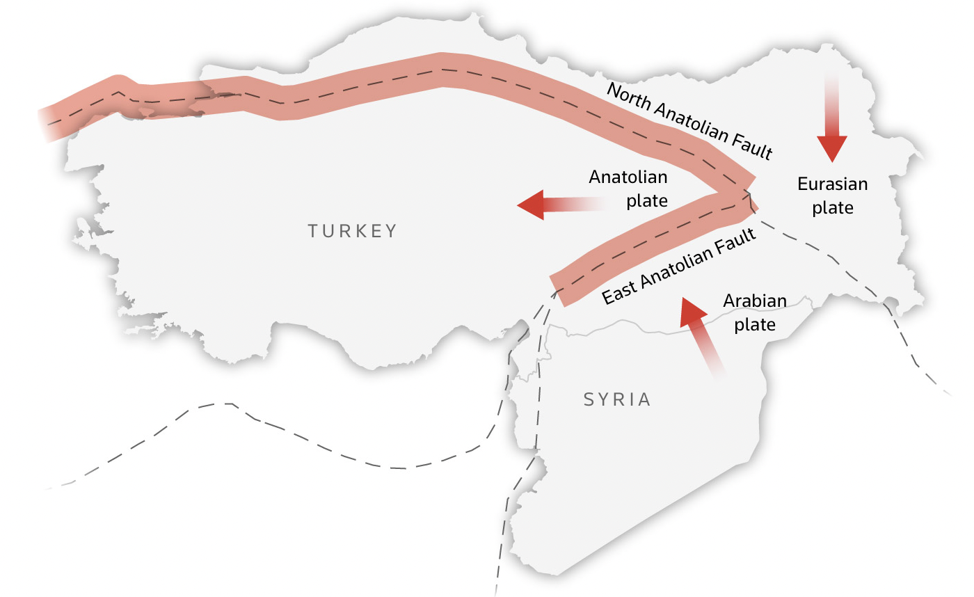
“earthquake activities mainly occur “on the Anatolian plate, a small wedge-shaped tectonic plate that is being squeezed westwards as the Arabian plate to the east slams into the Eurasian plate“. (emphasis added).
What characterizes Turkey’s earthquake activity is:
“a sequence along the North Anatolian Fault that started in 1939, causing large earthquakes that moved progressively from east to west over a period of 60 years”
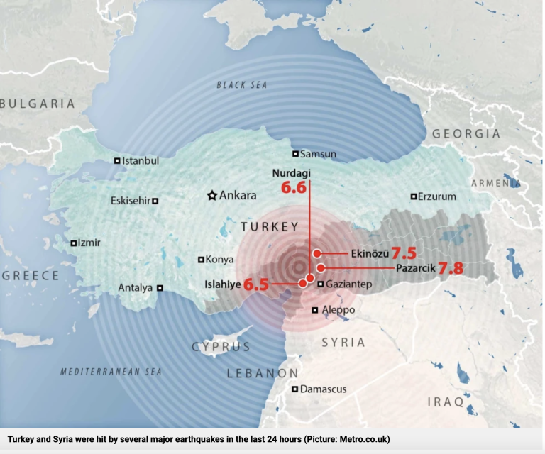
The February 6, 2023 earthquakes with epicentres in Pazarcik (7.8) and Ekinozu (7.5) respectively in proximity of Gaziantep and Kahramanmaraş are the largest “major earthquakes” in recent history. (See Table in Annex, Graph below).
On February 6, around 4:15 a.m. local time, a magnitude 7.8 earthquake struck south-central Turkey near the Turkey/Syria border. Just 11 minutes later, a magnitude 6.7 aftershock shook the region. Nine hours later a magnitude 7.5 quake followed. (USGS – National Earthquake Information Center)
The Map Below identifies the epicentres of the February 6, 2023 earthquakes, located in the South, within proximity of Syria’s Northwestern border.

Epicentre of Ekinozu, Pazarcik earthquakes, February 6, 2023
Recent “Major Earthquakes”
Historically, the largest earthquakes in Turkey have epicentres in North Western Anatolia, in proximity of Istanbul, Western Anatolia as well as in the Northeastern region.
The North Anatolian Fault
Seven large (MS) 7.0 earthquakes in the period from 1939 through 1999 along the North Anatolian Fault. See map above
These earthquakes have ruptured the fault progressively from east to west. Following are data for the seven large earthquakes that have progressively ruptured the North Anatolian fault:
- 1939 December 26. Magnitude (MS) 7.9 – 8.0. 30,000 deaths. Fault length about 360 km. Initiated the eastward migration of significant earthquakes on the North Anatolian fault. (Termed the 1939 Erzincan earthquake, North Anatolia)
- 1942 December 20. Magnitude (MS) 7.1. Fault length about 50 km. (Termed the 1942 Erbaa earthquake, North Anatolia)
- 1943 November 26. Magnitude (MS) 7.6. Fault length about 280 km. (Termed the 1943 Tosya earthquake, Northern Anatolia)
- 1944 February 01. Magnitude (MS) 7.3. Fault length about 165 km. (Termed the 1944 Bolu-Gerede earthquake, Northern Anatolia)
- 1957 May 26. Magnitude (MS) about 7. Fault length about 30 km. (Termed the 1957 Abant earthquake, Northern Anatolia)
- 1967 July 22. Magnitude (MS) 7.1. Fault length about 80 km. (Termed the 1967 Mudurnu Valley earthquake, Northern Anatolia)
- 1999 August 17. Ismit. Magnitude (MS) 7.8; MW 7.4-7.5) North Western Anatolia
Below are the reports of the 5 largest earthquakes since 1950 all of which are along the North Anatolian Fault
Bingol: a magnitude 6.9 and occurred in the eastern city of Turkey on May 22, 1971.
City of Izmit: August 17, 1999, 90 km southeast of Istanbul, 7.6 magnitude. The earthquake occurred in the industrialized and most densely populated urban areas of Istanbul, Sakarya, Golcuk, Darica, and Derince.
Düzce Quake, 12 November 1999, A major earthquake occurred 70 kilometers (45 miles) east of Adapazari or 170 km (105 mi) northwest of Ankara, A magnitude of 7.2.
The city of Van. 23 October 2011. A magnitude 7.1 earthquake, northeastern city close to border with Iran.
Izmir: of 30 October 2020, a magnitude 7.0 with an epicentre about 14 km northeast of the Greek island of Samos
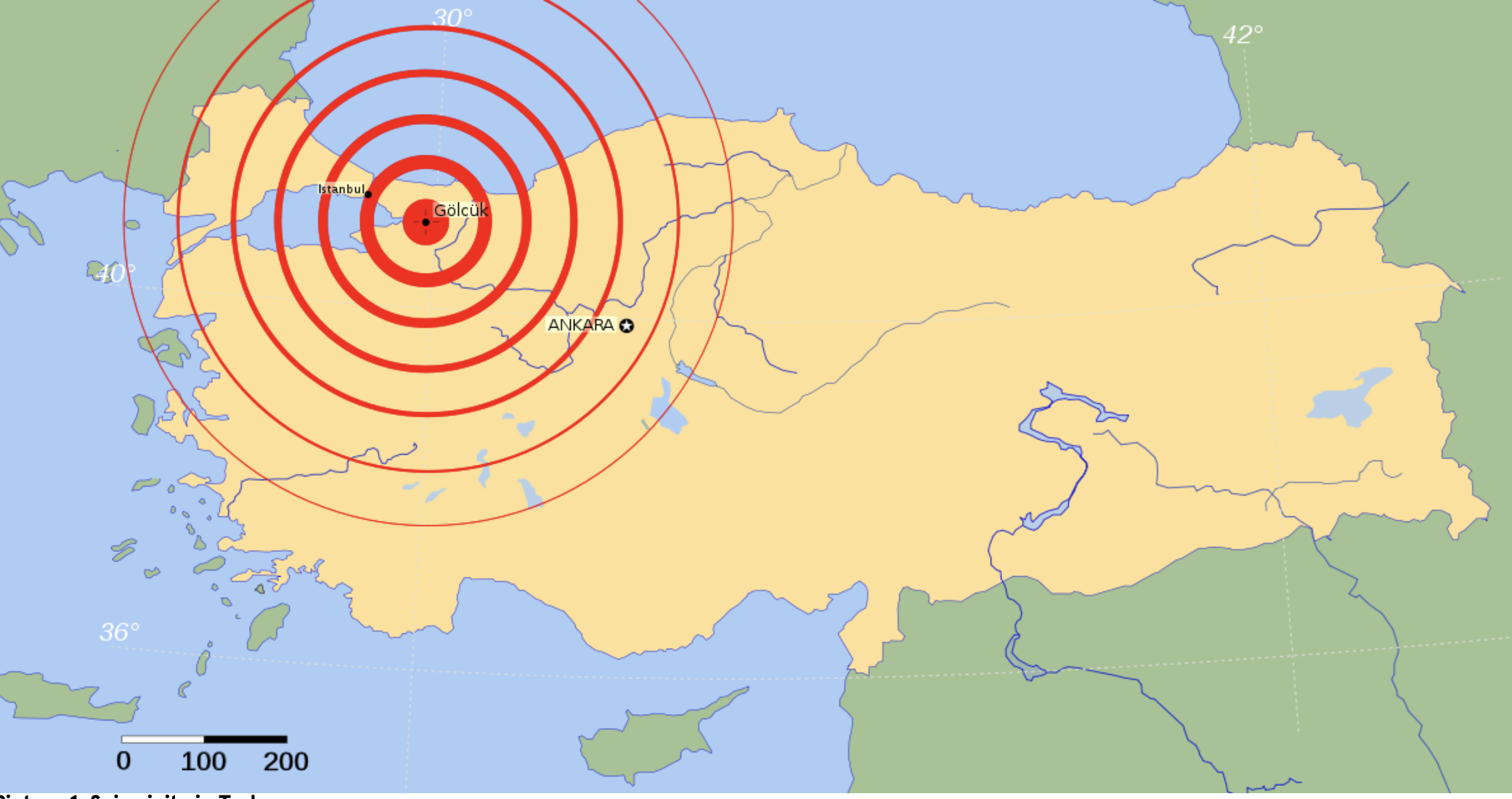
epicentre of Izmit-Golcuk earthquake in Northwestern Anatolia
Nota Bene: None of these major earthquakes (1939-1999) are in Southern Anatolia.
Long-Term History of Earthquakes in Turkey (342 AD -1999)
The history of “major earthquakes” is on record since 342 AD based on data compiled by the USGS – National Earthquake Information Center (See Table in Annex).
In the 13th Century, a “major earthquake” (60,000 deaths) was recorded in Adana in 1268 (Southern Anatolia). Moreover, since the 15th Century, all “major earthquakes” have occurred in Northwestern, Western and Northeastern Anatolia. (See Annex)
Southern Turkey Earthquakes
Reuters has categorized the initial major earthquake (February 6, 2023) “as the most powerful in the region in at least a century”. That is an understatement. In regards to Southern Anatolia, it is the largest earthquake in more than seven centuries. (Adana in 1268, see Table in Annex)
